Trekkers

  • Subscribe to our RSS feed.
  • Twitter
  • StumbleUpon
  • Reddit
  • Facebook
  • Digg

Thursday, 17 April 2008

3D buildings galore

Posted on 09:00 by Unknown
Posted by Bruce Polderman, Product Manager

Google Earth's "3D buildings" layer is now bigger and loads faster, making it better than ever! In Google Earth 4.3 you'll notice that we modified the sub-folder names in the "3D Buildings" layer to more accurately reflect the multiple sources of 3D data. "3D Warehouse" and "Other Buildings" have been replaced by "Photorealistic" and "Gray".


As the names imply, the "Photorealistic" folder consists of photo-textured 3D buildings, while the "Gray" folder contains untextured buildings, largely extruded building footprints.

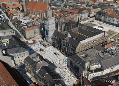
The "Photorealistic" folder contains buildings published to the 3D Warehouse, cities and towns of all sizes via the Cities in 3D program, as well as signature buildings and and auto-textured city models generated by Google. We're introducing tens of thousands of 3D buildings around the world for Google Earth users to explore. Included in the mix are dozens of urban centers including Oakland, San Francisco, Baltimore, Phoenix, Austin, Tampa, Orlando, Raleigh, Boston, Charlotte and Atlanta. In Europe, city models for Munich and Zurich now join Hamburg, which prior to today was one of the few complete cities models in Google Earth. In Asia, there are thousands of new buildings in dozens of Japanese cites, including Tokyo and Hiroshima.

San Francisco, CA

Boston, MA

Munich, Germany

Tokyo, Japan

We've been focusing our efforts on developing the larger cities around the world, but this shouldn't prevent smaller cities and towns who are eager to get on the map from participating as well. The Cities in 3D program provides an easy path for cities or local governments to efficiently contribute their data to Google. Some of my small town favorites are Boise Idaho, Amherst Massachusetts, and even the little hamlet of McMinnville, Tennessee.

Boise, Idaho

Models from 3D building enthusiasts account for a significant portion of the buildings in Google Earth. In fact, user-contributed models that meet our acceptance criteria are incorporated into the auto-generated cities. Better yet, data provided by users contains meta-data (such as an address, description, links, etc.) for the building. Please keep the those 3D buildings coming! The virtual 3D mapping of the world is really beginning to take shape and we'll need the continued support of the community to make this possible. If you'd like to take a crack at modeling a building for Google Earth, the tools are free and everything you need to get started can be found here.

This leads me to another new feature in Google Earth 4.3: we've made it easier to view a building's details. If you hover your mouse over a building that contains meta-data, the building will appear highlighted in blue just like a link on a webpage. When you click on the building, a Google Earth bubble appears displaying more information about the model. No longer do you have to sort through the yellow house placemarks!
I mentioned that it was faster, right? What I meant to say was *screaming* fast. Google Earth 4.3 loads an entire 3D city in seconds -- it's amazing to watch. Fly to any of the cities I mentioned, turn the "3D Buildings" layer on and see for yourself. To achieve our vision of creating a mirror-image of the earth we need deliver massive amounts of data to your desktop. To solve this challenging technical problem our engineering team developed an entirely new technology to more efficiently stream the massive volumes of 3D data available we'll continue to add to Google Earth.

I could go on forever, but I want to get back to exploring my new 3D world, and I'll leave you to start exploring for yourself!
Email ThisBlogThis!Share to XShare to Facebook
Posted in | No comments
Newer Post Older Post Home

0 comments:

Post a Comment

Subscribe to: Post Comments (Atom)

Popular Posts

  • In their own words
    Posted by Cathy Tang, Product Marketing Manager We're always amazed by the innovative ways businesses use Google Maps to improve their p...
  • The aftermath of Hurricane Ike
    Three days after Hurricane Ike slammed into Galveston, Texas as a Category 2 hurricane, severe flooding has challenged Gulf Coast residents ...
  • Making Maps and Earth Global
    Posted by Adam Smith, Geo Product Manager To have a truly global product, you need engineers from around the world to make it happen. Over t...
  • Every percent counts
    Posted by Chris Harrelson, Software Engineer, Google Transit The Google Transit team has been busy lately. In the last few weeks alone we...
  • Build Your Campus in 3D Competition - the results are in!
    Posted by Allyson McDuffie, Education Program Development Congratulations to the winners of Google’s Build Your Campus in 3D Competition ! A...
  • See which campuses received an A+
    Posted by Allyson McDuffie, SketchUp for Education Program Manager We are happy to announce the winners for the Google 2008 Internat...
  • Citizen journalism meets My Maps
    Posted by Jessica Lee, Product Manager I've noticed that lots of people are using My Maps to document breaking news and current events f...
  • We gotta start makin' changes
    Today we are relaunching one of our oldest and most popular Global Awareness layers, the Altas of Our Changing Environment by the United Na...
  • December Updates in Google Earth
    Posted by Wei Luo, Senior GIS Specialist Here's good news for the international folks: we've just added roads and business listings ...
  • YouTube-style Embeddable Maps
    Posted by Jess Lee, Product Manager, Google Maps Today we're excited to announce a new feature on Google Maps that allows you to add map...

Categories

  • gadgets
  • Map Maker
  • Mobile
  • Outreach
  • Quiz
  • real estate
  • Street View
  • Tip of the week
  • Transit

Blog Archive

  • ►  2009 (11)
    • ►  January (11)
  • ▼  2008 (257)
    • ►  December (17)
    • ►  November (16)
    • ►  October (27)
    • ►  September (33)
    • ►  August (16)
    • ►  July (20)
    • ►  June (17)
    • ►  May (25)
    • ▼  April (30)
      • Gettin' down (under) with a new Mapplet
      • Getting from A to B with Street View
      • Shaking things up
      • Google Maps in the news
      • Eco Everest expedition
      • Five factors to look for in Pennsylvania
      • Google Transit's Earth Day Challenge: the results ...
      • GeoWeb 2008
      • Dynamic data in Google Earth
      • It's all connected
      • Rise and Shine!
      • New ways to beat traffic with Google Maps
      • Touch down on the Earth's surface with Street View
      • 3D buildings galore
      • Swoop from space to the streets in Google Earth 4.3
      • Google Transit's early bird Earth Day launch
      • Introducing Google Earth 4.3
      • Terradex receives Environmental Achievement Award
      • YouTube videos in Google Maps
      • KML: A new standard for sharing maps
      • Google Earth gets Royal treatment
      • Worldwide wardrobe
      • Navigating the online real estate search
      • Google Transit arrives in Chicago
      • All the news that’s fit to print on a map: The New...
      • World is Witness
      • Where in the world is... (answers)
      • The 2008 Global Torch Relay
      • Last summer, somewhere in the Adirondacks...
      • Where in the world is...
    • ►  March (16)
    • ►  February (25)
    • ►  January (15)
  • ►  2007 (137)
    • ►  December (19)
    • ►  November (27)
    • ►  October (26)
    • ►  September (13)
    • ►  August (14)
    • ►  July (13)
    • ►  June (11)
    • ►  May (14)
Powered by Blogger.

About Me

Unknown
View my complete profile