Trekkers

  • Subscribe to our RSS feed.
  • Twitter
  • StumbleUpon
  • Reddit
  • Facebook
  • Digg

Monday, 27 August 2007

Track and explore real-time earthquakes and volcanic activity

Posted on 13:55 by Unknown
Posted by Scott Haefner and Dina Venezky, Geologists, U.S. Geological Survey (USGS)

The USGS monitors, assesses and issues warnings of natural hazards, including earthquakes and volcanoes. In the past month alone, a magnitude 8.0 earthquake shook Peru, Alaska’s Pavlof Volcano began erupting and lava started to flow from a new vent that formed in Hawaii's Kilauea Volcano. Now you can track both real-time earthquakes and volcanic activity on Google Maps using the USGS Mapplets.

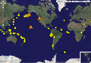
The Earthquake Mapplet plots the past week of earthquakes around the world, showing the location, time and magnitude. Each earthquake includes a link to the USGS earthquake website for more information, including additional parameters, background and other content such as Google Earth KMLs, ShakeMaps (shaking intensity maps) and "Did You Feel It?" maps.

The Volcano Mapplet displays the latest U.S. volcano updates, showing the current level of both ground-based and aviation hazards. Clicking on an alert icon provides a summary of the volcano update along with a link to the USGS Volcano Hazards Program website for additional details and images.


Give them a try and let us know what you think.
Email ThisBlogThis!Share to XShare to Facebook
Posted in | No comments
Newer Post Older Post Home

0 comments:

Post a Comment

Subscribe to: Post Comments (Atom)

Popular Posts

  • Helpful maps for the Inauguration
    There is most definitely a buzz in the air.  Hundreds of thousands of people are streaming into Washington D.C. to see Barack Obama sworn in...
  • Virtually experience the Inauguration
    Earlier today, we posted some tips about how to use Google Maps to be prepared for tomorrow's Inauguration. Well, for those who aren...
  • Tracking human development in Google Earth
    Posted by Megan Goddard, Senior GIS Specialist We're happy to let you know that the MDG Monitor , which launched last week at the Unite...
  • How's the weather?
    Posted by Cris Castello, GIS Data Engineer A wise man once said, "I ain't often right, but I've never been wrong." When i...
  • Your town in 3D
    Posted by Bruce Polderman, Business Product Manager We've all heard that big things come in small packages. Well, in the small town of M...
  • Happy Geography Awareness Week
    Some of my ear liest memories are of spreading National Geographic maps out on the floor of my living room, picking a faraway place on the p...
  • Think globally, mark locally
    Posted by Seth LaForge, Software Engineer, Google Maps The last time I threw a party, I used the My Maps feature of Google Maps to tell my ...
  • My Our Maps
    Posted by Jess Lee, Google Maps Product Manager The My Maps feature of Google Maps lets people create maps to share their hobbies and expert...
  • Introducing the MDG Monitor
    Posted by Ad Melkert, Under-Secretary-General and Associate Administrator, United Nations Development Programme As this space doesn't ha...
  • Where in the world is...
    Posted by Matt Manolides, GIS Specialist Greetings Earthlings, Today we've published a significant amount of new or updated 60cm satelli...

Categories

  • gadgets
  • Map Maker
  • Mobile
  • Outreach
  • Quiz
  • real estate
  • Street View
  • Tip of the week
  • Transit

Blog Archive

  • ►  2009 (11)
    • ►  January (11)
  • ►  2008 (257)
    • ►  December (17)
    • ►  November (16)
    • ►  October (27)
    • ►  September (33)
    • ►  August (16)
    • ►  July (20)
    • ►  June (17)
    • ►  May (25)
    • ►  April (30)
    • ►  March (16)
    • ►  February (25)
    • ►  January (15)
  • ▼  2007 (137)
    • ►  December (19)
    • ►  November (27)
    • ►  October (26)
    • ►  September (13)
    • ▼  August (14)
      • What's interesting around here?
      • Browsing geotagged photos from Picasa Web Albums
      • In-car Google Local Search with BMW ConnectedDrive
      • Track and explore real-time earthquakes and volcan...
      • Sky: The final frontier
      • YouTube-style Embeddable Maps
      • Real time Traffic in Google Earth
      • Google Book Search in Google Earth
      • Planning a trip using Google Maps
      • Maps for Educators
      • The 59 Mile Drive
      • More Street View Cities
      • Minnesota Bridge Collapse
      • How long will it take at rush hour?
    • ►  July (13)
    • ►  June (11)
    • ►  May (14)
Powered by Blogger.

About Me

Unknown
View my complete profile